

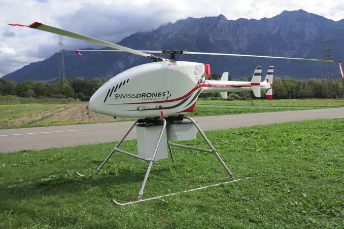
Large landfills and industrial sites are difficult to inspect efficiently from the ground. Drones extend coverage and reduce exposure, but a defensible survey still depends on flight planning, calibrated sensors, wind information and ground follow-up.
Why methane surveys move into the air
The starting risk is methane sources spread across large or hazardous areas where traditional inspection is slow or exposes personnel to unnecessary risk. Records, field observations and operating data should be checked together because any one source may be incomplete. The review should end with a question that field work can answer. Useful baseline information may include age, material, prior failures, consumption or flow records, site changes and customer reports. Gaps should be recorded rather than filled with assumptions.
Planning a defensible flight
The working sequence is straightforward: establish objectives, capture calibrated measurements across the site, relate concentration to wind and location, identify emission areas, calculate estimates where methodology permits, and direct verification teams. Each stage should have an owner and an acceptance check. This makes delays visible and shows whether the result changed maintenance, billing, safety or environmental performance. Completion records should show what changed after intervention. A second measurement, inspection or operational check is often the clearest proof that the original issue was addressed.
Collecting concentration and location data
Relevant methods include TDLAS, optical gas imaging, thermal sensing, GPS, wind measurements, photogrammetry, and analytical algorithms. They observe different signals and should be combined only when each method has a defined role. Instrument settings, calibration and site conditions belong in the final record. Where two methods overlap, the project plan should explain whether the second method is corroborating, locating or quantifying the first result. This avoids paying twice for evidence that answers the same question.
Adding wind information
The technical options include TDLAS, optical gas imaging, thermal sensing, GPS, wind measurements, photogrammetry, and analytical algorithms. Selection depends on what must be detected, located, measured or verified. A method that is excellent for screening may still need a more precise follow-up tool. Field teams should record environmental conditions and known sources of interference. Those notes allow reviewers to judge whether an apparent anomaly is credible and whether a return visit is necessary.
From plume detection to source location
The working sequence is straightforward: establish objectives, capture calibrated measurements across the site, relate concentration to wind and location, identify emission areas, calculate estimates where methodology permits, and direct verification teams. Each stage should have an owner and an acceptance check. This makes delays visible and shows whether the result changed maintenance, billing, safety or environmental performance. Completion records should show what changed after intervention. A second measurement, inspection or operational check is often the clearest proof that the original issue was addressed.
When quantification is justified
Planning for high-tech detection solutions requires more than equipment; it also needs qualified interpretation, assigned responsibility and usable records. The main constraints are quantification depends on methodology, wind characterization, flight geometry, calibration, and transparent uncertainty reporting. They belong in the technical scope because they can change accuracy, safety and usability. Critical findings may require confirmation by another method or physical exposure. The report should state confidence and explain what could not be determined. Honest limits help engineers choose safe follow-up work and prevent a preliminary finding from being used for a decision it cannot support.
Turning aerial findings into repairs
Done well, the program supports broader coverage, faster source screening, reduced exposure, and spatial evidence for repair planning. The business case is strongest when a baseline exists and the same indicators are checked after implementation. That allows managers to separate real improvement from normal variation. Performance review should compare like-for-like periods and account for operating changes. Otherwise, normal variation may be mistaken for improvement or a successful intervention may be overlooked.
What should teams confirm before an aerial methane survey?
They should confirm the asset type, operating condition, required accuracy and the decision the result must support. For this topic, the main constraints are quantification depends on methodology, wind characterization, flight geometry, calibration, and transparent uncertainty reporting. A short pre-field review should document those limits, identify any need for a second method and set the acceptance check for the final result.
How can owners verify the value of an aerial methane survey?
Verification starts with a baseline and a measure tied to the intended outcome. Expected gains include broader coverage, faster source screening, reduced exposure, and spatial evidence for repair planning. Owners should compare conditions before and after the intervention, confirm that priority findings were closed and record any recurrence. That produces a direct answer instead of relying on a vendor claim or an untested estimate.
Conclusion
Aerial detection is strongest when it directs precise, safe work on the ground. For asset owners responsible for landfills, pipelines, plants, and wide-area infrastructure, the next step is to define the decision, choose evidence that can support it and assign responsibility for follow-up. That approach keeps the work factual, measurable and useful after the initial survey or installation.